 INSPIRE Metadatensuche Österreich
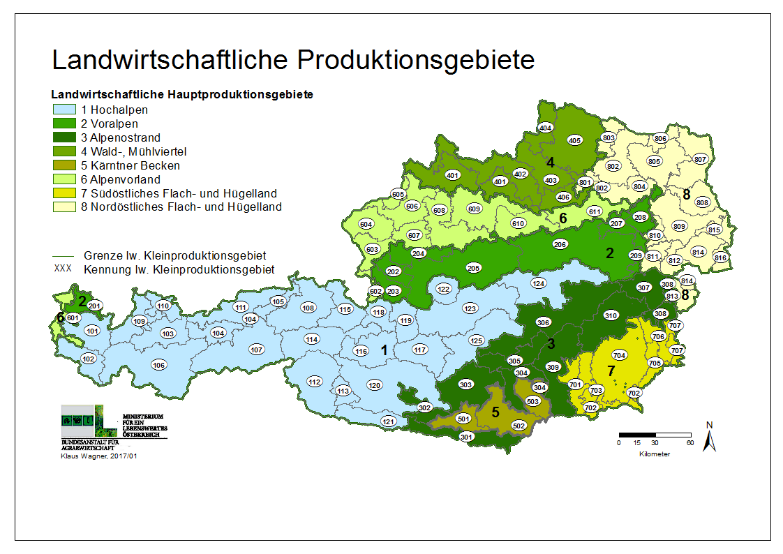
Landwirtschaftliche Produktionsgebiete Österreich
Landwirtschaftliche Klein- und Hauptproduktionsgebiete Österreichs auf Basis politischer Gemeinden. Zur Charakterisierung der sehr unterschiedlichen naturräumlichen Bedingungen in Österreich werden Regionen mit ähnlichen landwirtschaftlichen Ertrags- und Produktionsbedingungen zusammengefasst. Daraus ergeben sich 8 landwirtschaftliche Hauptproduktionsgebiete, welche sich wiederum in 87 Kleinproduktionsgebiete untergliedern. Nach Wagner, K. (1990): Neuabgrenzung landwirtschaftlicher Produktionsgebiete. Schriftenreihe der Bundesanstalt für Agrarwirtschaft Nr. 61 & 62. Wien.
Simple
- Datumsangaben (Überarbeitung)
- 2022-01-01
- Identifikator
- https://data.inspire.gv.at/0090/0ee1ee4a-bbca-4a48-99d9-de94ef492427
-
GEMET - Concepts, version 2.4
-
-
Landwirtschaft
-
Raumgliederung
-
Österreich
-
Regionale Gliederung
-
- Keywords
-
-
Agrargeographische Abgrenzung
-
- Zugriffseinschränkungen
- Benutzerdefinierte Einschränkungen
- Andere Einschränkungen
- No limitations on public access
- Nutzungseinschränkungen
- Benutzerdefinierte Einschränkungen
- Andere Einschränkungen
-
Namensnennung 4.0 International (CC BY 4.0)
- Anwendungseinschränkungen
-
keine Einschränkungen
- Räumliche Darstellungsart
- Vektor
- Sprache
- Deutsch
- Thematik
-
- Landwirtschaft
))
- Identifikator des Referenzsystems
- http://www.opengis.net/def/crs/EPSG/0/3035
- Identifikator des Referenzsystems
- http://www.opengis.net/def/crs/EPSG/0/4326
- Abgabeformat
-
-
GML
(
3.2.1
)
-
WMS
(
1.1.1
)
-
WFS
(
2.0.0
)
-
GML
(
3.2.1
)
- Online
-
Downloaddienst Landwirtschaftliche Produktionsgebiete Österreich
(
WWW:LINK-1.0-http--rss
)
Downloaddienst Landwirtschaftliche Klein- und Hauptproduktionsgebiete Österreichs auf Basis politischer Gemeinden
- Online
- Darstellungsdienst Landwirtschaftliche Klein- und Hauptproduktionsgebiete Österreichs auf Basis politischer Gemeinden (WMS) ( OGC:WMS-1.1.1-http-get-capabilities )
- Online
-
Downloaddienst Landwirtschaftliche Produktionsgebiete (WFS)
(
OGC:WFS-http-get-capabilities
)
Downloaddienst Landwirtschaftliche Klein- und Hauptproduktionsgebiete Österreichs auf Basis politischer Gemeinden (WFS)
- Bezugsebene
- Datenbestand
Konsistenz des Wertebereichs
- Verfahrensidentifikator
- INSPIRE / Conformity_001
Konformitätsergebnis
- Datumsangaben (Publikation)
- 2010-12-08
- Erklärung
-
siehe Referenzdokument (INSPIRE Technical Guidelines)
- Bestanden
- Ja
- Erläuterung
-
Landwirtschaftliche Klein- und Hauptproduktionsgebiete Österreichs auf Basis politischer Gemeinden. Zur Charakterisierung der sehr unterschiedlichen naturräumlichen Bedingungen in Österreich werden Regionen mit ähnlichen landwirtschaftlichen Ertrags- und Produktionsbedingungen zusammengefasst. Daraus ergeben sich 8 landwirtschaftliche Hauptproduktionsgebiete, welche sich wiederum in 87 Kleinproduktionsgebiete untergliedern. Nach Wagner, K. (1990): Neuabgrenzung landwirtschaftlicher Produktionsgebiete. Schriftenreihe der Bundesanstalt für Agrarwirtschaft Nr. 61 & 62. Wien. Basierend auf der Erstabgrenzung wird der Datensatz angepasst, wenn sich Gemeindegrenzen ändern, die im Grenzbereich mehrerer Produktionsgebiete liegen.
- Metadatensatzidentifikator
- 0ee1ee4a-bbca-4a48-99d9-de94ef492427 XML
- Sprache
- Deutsch
- Hierarchieebene
- Datenbestand
- Datum
- 2023-12-11T12:30:09
- Bezeichnung des Metadatenstandards
-
ISO19115
- Version des Metadatenstandards
-
2003/Cor.1:2006
Overviews
Räumliche Ausdehnung
Provided by
