INSPIRE Metadatensuche Österreich
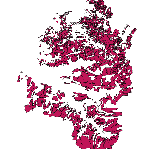
Alpen, Vor- und Maisäße Vorarlberg
Alpflächen, Maisäße und Vorsäße
Grundlage: Urmappe, Grundbuch und Alpdatenbank
Abbildung der Flächen durch Digitalisierung oder durch Zusammenfassen von Grundstücken einzelner Alpflächen.
Ist für INSPIRE gemeldet.
Wichtige Felder und Datentypen der Attributtabelle (jene, die inhaltliche Informationen enthalten):
Alpname (String)
Nutzung (String) Nutzung = (Alpe,Vorsäß,Maisäß)
Datenquelle: Alpen_Vorsaess_Maisaess.shp
INSPIRE
Identification
- Metadatensatzidentifikator
- 81be102a-f5bb-4e36-95e7-84afa238df71 XML
- Hierarchieebene
- Datenbestand
Online resource
- resource_protocol
-
OGC:WMS-http-get-capabilities
- resource_protocol
-
WWW:DOWNLOAD-1.0-http--download
- resource_protocol
-
OGC:WMS-http-get-capabilities
- resource_protocol
-
OGC:WFS-http-get-capabilities
- resource_protocol
-
WWW:DOWNLOAD-1.0-http--download
Resource identifier
- Sprache
- Deutsch
- Räumliche Darstellungsart
- Vektor
Encoding
- Format
-
ESRI Shapefile
- Version
-
-
Classification of data and services
- Thematik
-
- Wirtschaft
Classification of data and services
Coupled resource
Coupled resource
Classification of data and services
Coupled resource
Coupled resource
Keywords
-
GEMET - INSPIRE themes, version 1.0
-
-
Bewirtschaftungsgebiete/Schutzgebiete/geregelte Gebiete und Berichterstattungseinheiten
-
-
VOGIS-Thema
-
-
Landwirtschaft
-
-
VOGIS-Unterthema
-
-
Nutzung
-
-
GEMET - Concepts, version 3.1
-
-
Grünland
-
Bewirtschaftungsform
-
Nachhaltige Bewirtschaftung
-
Weide
-
-
Spatial scope
Other keywords
- Keywords
-
-
Alpen
-
Geographic coverage
))
Temporal reference
Temporal extent
- Begin
- 2013-01-01
- End
- 2017-03-31
Temporal extent
- Datum (Erstellung)
- 2010-01-10
- Datum (Überarbeitung)
- 2019-07-08T12:00:00
Quality and validity
- Lineage
-
Hersteller: Amt der Landesregierung, Abteilung Vc - Forstwesen
- Massstabszahl
- 5000
Conformity
Conformity
Conformity
Conformity
Conformity
Conformity
- Explanation
-
siehe Referenzdokument (INSPIRE Technical Guidelines)
Restrictions on access and use
- Access constraints
- Der öffentliche Zugang zu diesem Produkt unterliegt keinen Einschränkungen.
- Access constraints
- Namensnennung 4.0 International (CC BY 4.0)
- Access constraints
-
(c) Land Vorarlberg
Responsible organization (s)
Contact for the resource
- Organisation name
-
Vorarlberg, Amt d. LReg., Abteilung Va - Landwirtschaft und ländlicher Raum
- Organisation name
-
Vorarlberg, Amt d. LReg., Abteilung Va - Landwirtschaft und ländlicher Raum
- Organisation name
-
Vorarlberg, Landesamt für Vermessung und Geoinformation, Abteilung Geoinformation
- Organisation name
-
Vorarlberg, Amt d. LReg., Abteilung Va - Landwirtschaft und ländlicher Raum
Metadata information
Contact for the metadata
- Organisation name
-
Vorarlberg, Landesamt für Vermessung und Geoinformation, Abteilung Geoinformation
- Datum
- 2023-11-24T08:10:10
- Sprache
- Deutsch
SDS
Conformance class 1: invocable
Access Point URL
Endpoint URL
Technical specification
Conformance class 2: interoperable
Access constraints
Limitation
Use constraints
Limitation
Responsible custodian
Contact for the resource
Overviews
Räumliche Ausdehnung
Provided by